Maximizing Your Property’s Value: The Importance of Title Re-Establishment Surveys in Victoria
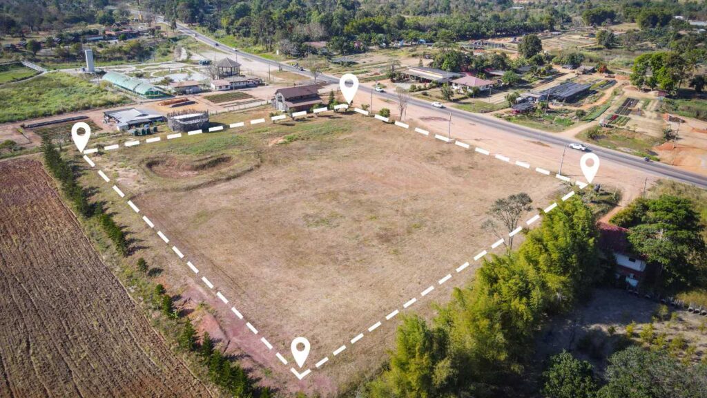
In the vibrant state of Victoria, a Title Re-Establishment Survey, commonly known as a Boundary Survey, plays a pivotal role in accurately determining and delineating the legal boundaries of your property as outlined in your Certificate of Title. This extensive survey rigorously analyzes the real physical characteristics present on your land, such as fences, buildings, and natural landmarks, and juxtaposes them against the officially recorded dimensions maintained by Land Use Victoria. By engaging in this survey, property owners can attain a comprehensive understanding of their land’s legal delineations, vital for making well-informed decisions regarding property development, real estate transactions, and adherence to local regulations.
It is crucial to emphasize that only a licensed land surveyor is legally authorized to conduct a title re-establishment survey. The findings from this survey are imperative for any property owner or developer who needs to accurately determine their boundaries prior to commencing construction, erecting fences, subdividing their land, or addressing boundary disputes. Having a clear grasp of your property limits can help you avoid serious legal complications in the future, ensuring peace of mind and security over your valuable investment.
Unlocking the Benefits: Key Insights from a Title Re-Establishment Survey
A meticulously executed title re-establishment survey not only identifies but also documents several essential aspects of your property that are crucial for property owners:
- The exact title boundaries and corner coordinates of your property, ensuring ownership clarity and preventing potential disputes.
- Identification of any existing encroachments from neighboring properties, including fences or structures that may overlap with your land, which could lead to conflicts.
- Thorough information regarding any applicable easements, restrictions, or rights of way that could significantly impact how you utilize your property.
- Identification of any discrepancies or errors between the actual land you occupy and the official title boundaries, facilitating timely corrections.
Your qualified surveyor will prepare a detailed survey plan and report that illustrates all boundary markers, relevant measurements, and their alignment with the official title plan maintained by Land Use Victoria. This documentation is invaluable for any future property transactions, developments, or legal matters, providing you with a solid foundation for making informed and strategic decisions.
Identifying the Right Time for a Title Re-Establishment Survey
It is prudent to arrange for a re-establishment survey before embarking on any projects that require precise boundary information. Consider scheduling this essential survey in the following scenarios:
- Building on or near a boundary, such as constructing a garage, extension, or retaining wall, which could potentially affect your neighbors and lead to disputes.
- Constructing a new fence or replacing an existing one, ensuring that it adheres to legal boundaries and complies with local regulations.
- Subdividing your property or establishing easements, which necessitates a clear understanding of boundary lines to avoid legal complications.
- Buying or selling land, particularly when boundary locations are ambiguous, to prevent future disputes that could stem from misinterpretations.
- Resolving boundary disputes or identifying encroachments that may escalate into conflicts with neighbors, thereby fostering good relationships.
Even minor inaccuracies in defining boundaries can lead to costly legal disputes or complications with regulatory compliance. By obtaining precise information early in the process, you can save significant time, reduce stress, and avoid unexpected expenses down the line, ensuring a smoother property development journey.
The Indispensable Nature of Title Re-Establishment Surveys for Property Owners
Your title is a vital document that delineates your legal ownership of the property. However, discrepancies can arise over time between the actual physical occupation of your land and the legal boundaries specified in your title. For example, fences may be reconstructed incorrectly, or structures could slightly encroach onto neighboring properties. Conducting a re-establishment survey is essential to ensure that your property aligns accurately with your legal title, thereby protecting your investment and averting disputes with neighbors or local councils.
These surveys are particularly critical when applying for subdivisions, boundary adjustments, or planning permits. Without an accurate title re-establishment, you risk delays or outright rejections from local councils and Land Use Victoria, which could impede your development projects and complicate your property dealings. Securing this survey not only streamlines your planning process but also strengthens your legal standing.
Step-by-Step Overview of the Title Re-Establishment Survey Process
- Consultation:
Your surveyor will conduct a thorough review of your Certificate of Title, subdivision plans, and any relevant documents to gather initial information essential for the survey, ensuring a comprehensive approach. - Fieldwork:
Utilizing advanced GPS technology and total station equipment, your licensed surveyor will visit the site to accurately locate existing boundary markers and physical features, guaranteeing precision in measurements. - Calculation & Comparison:
The data collected from the field will be meticulously compared with the title dimensions to identify any inconsistencies or potential encroachments that may need addressing, ensuring all discrepancies are highlighted. - Reporting:
A comprehensive plan will be developed, marking all boundary points, structures, and discrepancies. You will receive this plan in both digital and hard copy formats for your records and future reference, allowing you to keep track of important information. - Lodgement (if necessary):
If discrepancies are found, the surveyor can liaise with Land Use Victoria to resolve and update title information, ensuring that your records are accurate and legally compliant, thus safeguarding your interests.
Why City Land Surveyor Melbourne is Your Ideal Partner for Surveying Needs
At City Land Surveyor Melbourne, our dedicated team combines licensed expertise, cutting-edge technology, and local knowledge to deliver prompt, precise, and fully compliant re-establishment surveys. Our thorough surveys are recognized and accepted by councils, town planners, and building certifiers throughout Victoria, ensuring that you receive a service that meets all regulatory requirements and exceeds your expectations.
 Licensed and experienced Victorian surveyors Advanced GPS and total station technology for precise and reliable measurements Transparent, fixed-fee pricing to avoid unexpected costs and ensure budget compliance Detailed reports tailored for fencing, subdivision, and building applications, ensuring clarity and compliance with all regulations.
Get in Touch for Expert Boundary Surveying Solutions Today
If you are preparing for a renovation, planning a subdivision, or need expert assistance in resolving a boundary issue, City Land Surveyor Melbourne offers reliable and cost-effective surveying solutions across Greater Melbourne. Our committed team is dedicated to delivering the highest quality service tailored to meet your specific needs and expectations, ensuring you feel confident in your property dealings.
Call (03) 6163 3013 for free advice and a no-obligation quote, or visit citylandsurveyormelbourne.com to learn more about our comprehensive range of surveying services designed to meet your requirements.
Title Re-Establishment Survey in Melbourne: Your Essential Resource for Clarity and Compliance
The Article: Title Re-Establishment Surveys in Victoria Explained first appeared on https://writebuff.com
The Article Re-Establishment Surveys Explained for Victoria Residents Was Found On https://limitsofstrategy.com


This is such an important topic, and I really appreciate how you’ve highlighted the role of Title Re-Establishment Surveys in enhancing property value. I’ve seen firsthand how critical these surveys can be, especially in older neighborhoods where boundaries might not be clear due to decades of changes—fences put up without proper surveys, or multiple owners over the years not quite knowing where their property lines are drawn.